
Samsø Island in the Kattegat: Nature, Villages and Getting There
Samsø lies in the Kattegat between Jutland and Zealand, combining short distances with a surprisingly varied landscape. The Danish island is ideal for a cycling trip, village visits and coastal walks; ferries reach it from both Hou and Kalundborg.
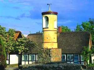 Glockenturm in Nordby auf der Insel Samsø
Photo: © Bent Næsby/VisitDenmark
Samsø at a glance
- Location: Danish island in the Kattegat between Jutland and Zealand.
- Size: around 114 square kilometres; the island is about 28 kilometres long and no more than seven kilometres wide.
- Landscape: coastlines, hills, valleys, heathland, fields and small villages lie close together.
- Highest point: Ballebjerg rises to 64 metres and offers sweeping views across the Kattegat.
- Getting there by ferry: Hou–Sælvig connects Samsø with Jutland, while Kalundborg–Ballen connects it with Zealand.
- Cycling: short distances and a route linking Tranebjerg with Nordby make it easy to plan island rides.
What makes Samsø a distinctive destination
Samsø is not a Baltic Sea island; it lies in the Kattegat. This matters when planning a trip: the island can be explored as a destination in its own right, with links to mainland Denmark, and is accessible via two ferry ports. Across the island’s roughly 114 square kilometres, coastlines, fields, villages and rolling countryside alternate. Its elongated shape means short cross-island journeys as well as varied routes running north to south.
The landscape has been shaped by glacial features and centuries of farming. Alongside cultivated fields are pastures, wetlands, heathland and woods. The hills and pastures are especially striking in the north; in the south, routes open up to more stretches of coastline and the historic site of Vesborg. So if you are looking for more than just a swimming spot, Samsø offers a destination where nature, villages and small cultural attractions come together.
Nordby, Tranebjerg and the island’s villages
Nordby in the north is a good starting point for discovering the island’s village architecture. The settlement retains a cohesive historic character, with low houses and farmsteads clustered around the village centre. Its famous yellow bell tower dates from 1857. A walk through the streets can be combined with a detour into the surrounding hills. At Ballebjerg, the island’s highest point at 64 metres, stands a viewing tower built in 1920. On a clear day, the view stretches across the Kattegat towards Tunø and Aarhus, as well as to the small islands east of Samsø.
Tranebjerg is centrally located and is the island’s largest settlement. Its position makes it a convenient stop on a north–south tour and a useful point of reference for errands and onward journeys. Smaller villages are scattered between the two, each with its own centre and farming surroundings. On a first visit, rather than trying to tick off as many places as possible, it makes sense to choose a northern or southern circuit and allow time for walks and breaks.
In the south, Vesborg Fyr offers a different perspective on Samsø’s history. The lighthouse was built in 1858 on the site of a medieval castle. It stands at the island’s southwestern tip, where its position opens up views of the southern Kattegat and the approaches to Lillebælt and Storebælt. The remains of ramparts and an exhibition in the powder house recall the former fortifications. The visit combines landscape and history without requiring a full day.
Cycling and routes through the countryside
The manageable distances make cycling an especially suitable way to discover Samsø. A signposted route runs from Tranebjerg in the centre of the island to Nordby. This makes it easy to combine a village visit in the north with a stop in the middle of the island. The route can be planned as a longer day ride or split into separate stages. If you are cycling with children, you can add village stops and longer breaks.
When planning your ride, it is worth deciding between a direct route and a more scenic loop. The direct route leaves more time for Nordby or a detour to the coast; a loop passes closer to fields, hedgerows and small lanes. Samsø is mostly flat, but some hills add climbs and viewpoints to the ride. Wind and weather are more noticeable on an island than on a sheltered city route. A shorter route with a planned break therefore leaves more room for spontaneous stops.
In natural areas, meadows, pastures and privately owned woodland are all part of the landscape. In the northwest, marked walking trails pass through an extensive area of pastureland; in Brattingsborg Skov and the plantation between Kanhave Canal and Mårup, permitted paths cross privately managed land. Please stay on the paths and follow local signs. This makes it possible to enjoy nature while respecting farming and property.
Ferries and travelling to Samsø
The ferry port you choose depends on where you are travelling from. Ferries run from Hou in Jutland to Sælvig on Samsø; according to the operator, the crossing takes about 60 minutes. The route from Kalundborg on Zealand goes to Ballen and takes about 80 minutes. Both services carry cars and bicycles and also allow foot passengers. Travelling in your own vehicle gives you the flexibility to combine your accommodation and island itinerary as you wish. Without a car, the Telebus connects destinations across Samsø from address to address, making it possible to plan onward travel from the ferry port to Tranebjerg or Nordby.
Timetables and available departures vary by route and season. Be sure to plan your reservation, vehicle space and departure time in advance with your chosen ferry operator. For the Kalundborg crossing, the operator recommends booking ahead to secure a place. Staying overnight near Ballen can make the arrival or departure day more relaxed on this route; its location by the ferry port also makes it a natural first stop.
The Telebus operates from address to address by advance booking; rides must be booked at least two hours ahead, and passengers should be ready one hour before the agreed pickup time. It runs Monday to Friday and Sunday from 7 am to 9 pm, Saturdays from 7 am to 7 pm, and daily for early ferry departures. The scheduled school buses run in the morning between 7 and 8 am; in the afternoon, other passengers can board in Tranebjerg and Onsbjerg and travel to the stop closest to their destination. This makes it possible to plan car-free onward travel using a Telebus booking or local bus services.
For choosing accommodation, it helps to think in terms of the island’s different areas: accommodation on Samsø gives you an overview of the island, accommodation in Ballen suits arrivals via the eastern harbour, and accommodation in Kolby offers a base for the southern part of the island and Vesborg Fyr. For a cycling trip that takes in churches and village history in the south, Ørby can also make a suitable base. The best choice depends on your planned excursions and whether you intend to explore the island by car, bicycle or on foot.
What kind of trip suits Samsø?
For a first visit, a combination of Nordby and a ride via Tranebjerg is a good option. By bicycle, you can split the journey into several stages; by car, you will have more time for a detour to Ballebjerg or the south. If you want to experience the landscape mainly on foot, choose a marked trail in the north and add a walk through a village. A trip to Vesborg Fyr adds a historical focus and works well as part of a southern island loop.
For a short stay, let the ferry crossing shape your day’s plans. Arriving in the morning leaves time for a first stop on the island; if you arrive later, explore Ballen harbour and the surrounding area and save longer journeys for the following day. On a longer trip, you can explore the island in sections: Nordby and the northern hills, Tranebjerg in the centre, and the coastal villages and Vesborg in the south. This keeps travel times manageable and leaves room for spontaneous breaks.
Samsø is particularly well suited to travellers who enjoy alternating between outdoor activities and quiet village visits. The appeal lies less in a single major attraction than in the combination of routes, coastal scenery, farming and small settlements. Travelling with children? Choose short cycling stages and clear stopping points. For a cultural trip, Nordby’s historic village layout and Vesborg Fyr provide specific highlights. For a nature-focused trip, pastures, heathland, coastlines and viewpoints are all close together.
Each season offers something different for a nature-and-village route: in spring, birds pass through Nordby Bakker and the slopes are in bloom; in summer, you can combine the scenery with swimming breaks. Migrating birds return in autumn, when berries dot the hills, while winter is ideal for peaceful walks through the countryside. This means Nordby and Ballebjerg can be experienced differently throughout the year and combined with a detour to historic Vesborg Fyr.
Frequently asked questions about Samsø
Is Samsø in the Baltic Sea?
No. Samsø lies in the Kattegat between Jutland and Zealand. The island is part of Denmark and can be reached from the mainland via the ferry ports of Hou or Kalundborg.
How do you get to Samsø from Jutland?
The car ferry runs from Hou to Sælvig. The crossing takes about 60 minutes. For the connection with Zealand, ferries run from Kalundborg to Ballen; the crossing takes approximately 80 minutes.
Can you explore Samsø by bicycle?
Yes. The short distances and the route between Tranebjerg and Nordby are well suited to cycling around the island. For a leisurely ride, combine cycling stretches with breaks in villages or at viewpoints.
What is a good first outing on the island?
Nordby and Ballebjerg combine a historic village walk with a viewpoint. If you are interested in medieval history, add Vesborg Fyr in the south, where the lighthouse, castle site and exhibition come together.
