
Hiking between Hasle, Teglkås and Vang
Between Hasle, Helligpeder, Teglkås and Vang, Bornholm’s west coast reveals its fishing heritage, steep cliffs and traces of granite quarrying. The route includes steep climbs and the steps at Jons Kapel; sure footing and grippy shoes are advisable on the uneven coastal paths.
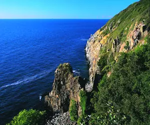 Jons Kapel auf der Insel Bornholm
Photo: © Henrik Stenberg/VisitDenmark
Quick facts about Helligpeder, Teglkås and Vang
- The western coastal route passes through three former fishing settlements and ends in Vang, which rises in terraces above the harbour.
- An official Bornholm tour describes a route of around 7 kilometres from Teglkås to Vang; the path begins with a steep climb.
- Jons Kapel can be reached by a steep staircase on the cliff; the route includes exposed, rocky stretches of coast.
- Ringebakkerne features former quarries, spoil heaps and a striking art bridge over a blasted access road.
- Vang Watermill is a restored watermill dating from the early 19th century; it is the only surviving mill on Bornholm with an overshot waterwheel.
- Small fishing harbours in Helligpeder and Teglkås, along with the smokehouse in Teglkås, recall the coast’s maritime past.
- The high-level route can be combined with a visit to Vang harbour and the mill; grippy shoes are advisable for the rocks and steps.
Stages along the west coast
The three places lie on Bornholm’s western coast between Hasle and Vang. Helligpeder and Teglkås were small fishing settlements; their tiny harbour basins and buildings tell of a time when fishing and smoking fish were part of everyday life. The smokehouse in Teglkås is an easy-to-spot landmark. Vang developed more through granite quarrying: the cliffs and quarries explain why the harbour and settlement are so closely tied to the steep coastal landscape.
For planning a hike, the official route suggestion from Teglkås to Vang is the clearest option: it covers around seven kilometres. The walk starts at the car park behind Teglkås; from there, the path climbs and soon reaches the cliffs high above the water. If you are coming from Hasle, you can include it as a southern starting point for your drive or as part of a longer stage, but don’t mistake the seven kilometres for the total distance from Hasle. The coastline is varied, with village paths, exposed cliff edges and former quarry sites following one another.
Helligpeder and Teglkås make good short stops for a close look at their harbours and fishing heritage. The villages are small; their attractions are more about their setting, harbours and scenery than a packed programme of museums. In Teglkås, the village centre connects with the entrance to the coastal route. Allow time for the transition from the village to the elevated walking path, rather than treating the place names as a series of quick stops one after another.
Jons Kapel: cliff, steps and a detour
North of Teglkås stands Jons Kapel, a striking rock formation by the sea. Legend has it that a monk named Jon preached to the people of Bornholm from there. For visitors, the contrast between the high ground and the rocky shore is especially interesting: from above, you can look out over the steep coast, while a stony beach lies below. The steps down are steep and can be slippery when wet. If you plan to descend, you’ll need sure footing, and should not consider the detour an essential part of the hike.
The coastal path itself runs above the water and is steep and uneven in places. In stronger westerly winds, waves crash against the cliffs; rough seas can make it difficult to return from the shore. A sensible approach is to assess the descent and the coastal conditions first, then decide whether a visit to the beach is suitable. The terrain is exposed and offers little shelter from the wind. A light shower, slippery ground or tiredness after climbing the steps are all good reasons to continue along the upper path instead.
Remnants of the old rescue route can be found in the area. It was used to rescue people from shipwrecks along stretches of coast that were difficult to access. This explains the steps and tracks through the rocky landscape as part of historic infrastructure. Follow marked routes while hiking and stay on the paths, especially on steep sections. Nature areas and quarry sites are not shortcuts to viewpoints.
Ringebakkerne and the history of granite
After Jons Kapel, the route continues through the rolling landscape of Ringebakkerne. Old quarries have cut deep into the terrain; some excavated areas have filled with water, while the rock faces show where stone was once extracted. A narrow bridge crosses the blasted access road to the coast and is a notable point along the route. The combination of woodland, open slopes, quarry and cliff makes this stretch different from an ordinary coastal path.
The bridge is also a useful landmark: from here, it becomes clear how granite quarrying has shaped the landscape. In Vang, the story continues at the harbour, whose former role was linked to shipping stone. A monument made from reused stones commemorates this work. Today, Vang is a leisure harbour with several basins; the village rises in terraces up the hillside, making the path down to the water steep.
Vang Watermill is the only surviving Bornholm mill with an overshot waterwheel. It was built in 1811 and stood on the Ringebækken stream; millponds supplied water to power it. The restored site near Vang illustrates the connection between water, the slope of the land and the use of energy in the past.
Route, return journey and planning your visit
The seven kilometres from Teglkås to Vang make this a linear hike, so you’ll need to plan your return. If you arrive by car, you can’t easily join the start and finish into a circular route; your plans for the day should include either a second car or a suitable bus connection. Buses stop on the main road above Vang; from there, it is about a ten-minute walk down to the harbour. The steep descent to the water is an extra section and should be factored into your return journey.
For a short visit, it makes sense to focus on one highlight: perhaps Helligpeder and Teglkås for harbour views, Jons Kapel and its steps, or Vang with its mill and harbour. If you walk the whole route, allow extra time for detours, taking photos and breaks on the heights. The exact walking time depends on your pace, the terrain, the weather and whether you choose to descend to the beach. The exposed cliff sections offer little shade, so bring water and weather protection.
The route features steep climbs, steps and uneven ground; these sections make it more demanding than the distance alone might suggest. If you are unsure on your feet, you can view Jons Kapel from above and skip the descent. If you are travelling with children, keep them close near cliff edges. For more ideas for your island itinerary, the Bornholm overview adds other landscapes and places to this coastal walk; the town of Hasle offers a southern reference point, with a harbour and smokehouse. More cultural and natural attractions are featured in Bornholm day-trip ideas.
For accommodation near the southern part of the route, Hasle is a good base. From there, you can divide visits to the coast, Teglkås and Vang into day trips. If you want to stay near the walking route, consider the accommodation’s actual location together with how you’ll get back to your starting point; the road runs through the island’s interior, not along a flat footpath by the water.
Frequently asked questions about Helligpeder, Teglkås and Vang
How long is the hike from Teglkås to Vang?
The official route from Teglkås via Jons Kapel and Ringebakkerne to Vang is around seven kilometres long. Starting in Hasle makes the route longer.
Is the staircase at Jons Kapel suitable for everyone?
No. The steps are steep and can be slippery. The descent requires sure footing; you can also view the rock formation from above and skip the stairs.
Is the watermill in Vang Bornholm’s only one?
No. The mill is one of the island’s surviving watermills. However, it is the only surviving mill on Bornholm with an overshot waterwheel.
