
Neringa: Curonian Spit, Dunes and Cycle Route
Neringa is a municipality on the Lithuanian part of the Curonian Spit, a narrow strip of land between the Baltic Sea and the Curonian Lagoon. It includes Nida, Juodkrantė, Preila and Pervalka. A 52-kilometre cycle path connects the settlements from Smiltynė to Nida.
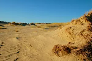 Wanderdüne auf der Kurischen Nehrung
Photo: © bretagne 32 / pixelio.de
Neringa at a glance
- Location: Lithuanian part of the Curonian Spit, between the Baltic Sea and the Curonian Lagoon.
- Settlements: Nida, Juodkrantė, Preila and Pervalka are part of the municipality.
- Landscape: Dunes, pine forests and lagoon shores define the route.
- Cycling route: A renovated, almost flat cycle path runs for around 52 kilometres between Smiltynė and Nida.
- Access: A ferry from Klaipėda crosses the Curonian Lagoon to Smiltynė.
The settlements of the spit as stages of a trip
Nida makes a good base for visiting the Thomas Mann House and Parnidis Dune in the southern part of the spit. The signposted 1.1-kilometre educational trail to the dune starts at Neringa Sports School in southern Nida and leads along wooden walkways and steps to the sundial plaza and its viewing platform. Juodkrantė is a stop farther north: the Hill of Witches, with its wooden sculptures, is in the settlement. The Nagliai Nature Reserve and its Grey Dunes, by contrast, lie between Juodkrantė and Pervalka; a separate entrance to the reserve’s visitor trail is located at kilometre 32 of the Smiltynė–Nida road. Pervalka and Preila are smaller settlements farther south along the cycle route to Nida.
The Curonian Spit is a narrow natural landscape where the Baltic Sea and the lagoon lie close together. Forests, dunes and open shores alternate along the route. When planning your trip, it is therefore important to consider the different sides of the landscape and the distances between settlements. The Lithuanian coastal city of Klaipėda is the gateway from the mainland; for a seaside promenade and an amber museum, Palanga adds a different coastal character to the trip.
Cycling between Smiltynė and Nida
The official cycle route is about 52 kilometres long and passes through all of Neringa’s settlements. It forms part of Lithuania’s Seaside Bicycle Route and the “Hansa” EuroVelo route. The route runs mostly through pine forest and is almost flat, according to the local tourism information centre. The northern section from Klaipėda to Juodkrantė is 21 kilometres long, followed by another 16.5 kilometres from Juodkrantė to Pervalka. From there, the path continues via Preila to Nida.
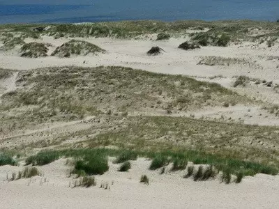
The Nagliai Nature Reserve, with its Grey Dunes, lies between Juodkrantė and Pervalka. The official entrance to the educational trail, which is just over a kilometre long, is at kilometre 32 of the Smiltynė–Nida road, next to the car park; the trail alternates between compacted gravel and wooden surfaces, as well as sand. In the reserve, visitors must stay on the designated paths, whether walking or cycling. Vecekrugas Dune and Cape Bulvikis are also along the cycle route; viewpoints and birdwatching towers between Pervalka and Nida offer places to rest. Bicycles can be rented in Neringa. If you want to cycle the entire route, you can plan the settlements as intermediate stops; for a shorter outing, choose individual sections between neighbouring settlements.
The cycle route starts at one of the ferry terminals to Smiltynė in Klaipėda. The Old Ferry is for pedestrians and bicycles; the New Ferry also carries vehicles. Choose the terminal according to whether you are taking a car across to the spit or continuing on foot or by bicycle without a car. Once in Neringa, the signposted route connects the settlements all the way to Nida.
Nature, views and guided visits
If you want to get to know the spit in a day, guided tours are an alternative to planning your own stages. The local tourism centre offers a six-hour tour of the dunes, pine forest, fishing villages, the Hill of Witches, the cormorant colony, the Thomas Mann summer house and Parnidis Dune. The tour is offered in Lithuanian, English and Russian; the guide accompanies the group in its own vehicle. Advance booking is required.
If the Thomas Mann House and Parnidis Dune are your main interests, Nida is a convenient base: both are located there, and the educational trail to the dune starts in the southern part of the settlement. Juodkrantė makes a good stop farther north for a visit to the Hill of Witches; from Klaipėda, it is 21 kilometres by cycle route to Juodkrantė and another 16.5 kilometres to Pervalka. The entrance to the Nagliai trail is between Juodkrantė and Pervalka, at kilometre 32 of the road; Preila comes next along the route between Pervalka and Nida. This makes Pervalka and Preila easy to include as stops on a longer trip along the spit. The accommodation overview for Neringa brings together local options for these different stages; the nationwide Lithuania overview places the spit in the context of the Baltic coast, alongside Palanga and Klaipėda.
Frequently asked questions about Neringa
Which settlements are part of Neringa?
The municipality includes Nida, Juodkrantė, Preila and Pervalka on the Lithuanian part of the Curonian Spit.
How can you explore the spit without a car?
The ferry from Klaipėda to Smiltynė lets you continue on foot or by bicycle. The roughly 52-kilometre cycle path connects all the settlements as far as Nida; individual sections are suitable for shorter rides.
Which places are good for a first visit?
In Nida, combine a visit to the Thomas Mann House with the 1.1-kilometre educational trail to Parnidis Dune, which starts at Neringa Sports School and ends at the sundial. The Hill of Witches is in Juodkrantė; the entrance to the trail through the Grey Dunes is separate, at kilometre 32 of the road to Nida. Visitors to the Nagliai Nature Reserve must stay on the designated paths. A guided tour connects several places on the spit in a single day.
