
Sæby on the Kattegat: Harbour, Coastal Paths and Town Centre
The four Kløverstier routes in Sæby start at the harbour and pass through natural areas, the historic town centre and the harbour promenade. The municipal route overview lists distances of 2.5, 5, 7.5 and 21.5 kilometres. The Nordsøstien also passes through the harbour.
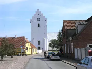 Kirche in Sæby
Photo: © Lukas Riebling Wikimedia CC BY-SA 3.0
Sæby at a glance
- Starting point for the four Kløverstier routes: Havnen 2 in Sæby.
- The four distances: 2.5, 5, 7.5 and 21.5 kilometres.
- The Nordsøstien also passes through the harbour; within the municipality, it follows the east coast.
- The municipal route overview lists asphalt, gravel and natural trails as the surfaces on Sæby’s routes.
Routes between the harbour and town centre
The harbour is the common starting point for the Kløverstier routes. Frederikshavn Municipality describes them as routes through Sæby’s natural areas, historic town centre and harbour promenade, with short stories about the town along the way. The shortest loop is 2.5 kilometres, and the longest is 21.5 kilometres. Two other routes of 5 and 7.5 kilometres are available in between. This means you can fit a short walk into a visit to the town or choose a longer hike as an activity in its own right.
The routes run along asphalt, gravel and natural trails. The municipal nature guide also describes Gybels Plantage, right in the middle of Sæby: two of the Kløverstier routes pass through the area. There is a path through the forest, as well as a dog forest. This makes the plantation a specific natural section of the local trail network, rather than a separate excursion destination outside town.
Coastal paths and nature south of the harbour
The Nordsøstien passes through the harbour and continues as a long-distance hiking trail along the east coast. The municipal overview describes a total of 132 kilometres of this route in Frederikshavn Municipality. If you are staying for a shorter time, you can combine it with one of the local Kløverstier loops; the different distances let you choose how far to walk, without assuming a particular day’s itinerary.
South of Sæby, forest, heathland and the Kattegat coast meet in Professorens Plantage. The municipality describes a path through the forest and along its edge, with open coastal heathland to the east. Another path leads from the plantation to the Nørklit holiday-home area. This landscape is therefore distinct from the paths that start directly at the harbour and in the town centre.
Sæby as a base
If you want to start exploring the trails on foot, you can use the accommodation options in Sæby as a base: the municipal starting point for the Kløverstier routes is at the harbour, and two routes pass through Gybels Plantage. For another coastal town, you can pair Sæby with Frederikshavn; both towns are on the east coast of North Jutland. The island of Læsø in the Kattegat is a separate island destination in the region.
Frequently asked questions about Sæby
Where do the Kløverstier routes start?
According to Frederikshavn Municipality, all four routes start at the harbour, Havnen 2 in Sæby. From there, they pass through natural areas, the historic town centre and the harbour promenade.
How long are the four routes?
The municipal website lists distances of 2.5, 5, 7.5 and 21.5 kilometres. The routes use asphalt, gravel and natural trails.
Which paths continue along the coast?
The Nordsøstien passes through the harbour and follows the east coast. South of town, a path leads through Professorens Plantage and along the coastal heathland.
