
Northern Jutland: Skagen, the Kattegat, and the Limfjord
Northern Jutland brings together Skagen’s wind-shaped northern tip, the beaches along the Kattegat, and towns on the Limfjord. For planning a trip, which coast you choose matters: around Skagen, open seascapes and shifting dunes define the experience, while farther south you’ll find harbors, island ferry connections, and seaside resorts.
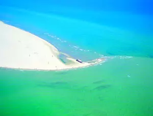 Blick auf Kap Skagen
Photo: © oben: Thomas Nykrog/VisitDenmark, unten (2): nordlicht verlag
Northern Jutland at a glance
- Northern Jutland stretches between the North Sea and the Kattegat, reaching Grenen headland near Skagen.
- The Skagerrak and Kattegat meet at Grenen, where changing currents shape the sandy spit.
- Råbjerg Mile is a shifting dune about 40 meters high that moves roughly 15 meters northeast each year.
- The Limfjord divides the northern part of Jutland and connects towns on both shores.
- Ferries from Frederikshavn connect to Gothenburg and the island of Læsø.
- Aalborg combines its Limfjord setting with museums, architecture, and urban culture.
Discover the North Sea, Skagerrak, and Kattegat
The North Sea and Skagerrak lie to the west, while the east coast faces the Kattegat. The Limfjord cuts deep into Jutland, with the northern mainland area of Vendsyssel-Thy lying beyond the fjord. These waterways help explain why trips between coastal towns, cities, and ferry ports often reveal very different landscapes. If you’re focusing on the northern tip, the Skagen destination guide offers an overview of the town and its surroundings.
At the tip of Grenen, waves from the Skagerrak and Kattegat meet. Currents reshape the sandy, pebbly shore, and over the past century the headland has continued to grow farther out into the sea. The beach is a place to observe coastal forces, go for a walk, and watch birds. Swimming is prohibited because of dangerous currents. South of the tip, a compass rose indicates that Grenen actually faces east—an unusual orientation for Denmark’s northernmost point.
Four hiking trails lead from the parking area to the tip; one is paved and suitable for bicycles, wheelchairs, and strollers. In season, Sandormen, a tractor-pulled vehicle, also takes visitors to the beach. A walk across the sand can be combined with a visit to Skagen, whose yellow houses, harbor, and art history contrast with the open headland. In spring, the area is considered an important place to watch birds of prey; seals also occasionally rest on the beach. When planning the day, allow for changing coastal conditions and choose a suitable route on foot.
Shifting dunes and culture around Skagen
Råbjerg Mile shows just how changeable the landscape of Northern Jutland can be. The dune is about one kilometer wide and long, roughly 40 meters high, and made up of approximately 3.5 million cubic meters of sand. It moves about 15 meters northeast each year, toward Grenen. Crossing the sandy expanse brings the dune’s scale and movement into sharp focus, while the ground shapes and small hollows change along the way. The open sand makes a visit a very different experience from a walk along a vegetated stretch of coast.
The shifting sand has also shaped the area’s history. In the past, moving sand covered land around Skagen; the tower of the sand-covered St. Laurentii Church is a visible reminder of this. Råbjerg Mile and Grenen make two distinct excursions: one shows the movement of the inland landscape, while the other reveals how sea currents shape a headland. If you visit both in one day, allow time for walking on the sand and spending time by the coast.
Skagen complements its natural attractions with harbor life and art. At the end of the 19th century, the distinctive light drew artists to the area, and the artists’ colony remains part of the region’s cultural history. Skagens Museum displays works by the Skagen Painters. In Aalborg, the Aalborg city guide offers an introduction to the old town and the Limfjord waterfront. The Utzon Center on the waterfront brings together architecture and design in a building designed by Jørn Utzon with his son Kim. The Utzon Gallery and changing exhibitions give the visit a focus on architectural history.
The Limfjord, Aalborg, and the towns on the east coast
Aalborg makes a good urban counterpoint to the open coastal landscapes. The city lies on the Limfjord and is well suited to a walk through the old town and along the waterfront. The Utzon Center was completed in 2008; its waterside location reflects the maritime environment that shaped Jørn Utzon from childhood. If you’re adding architecture to your itinerary, you can combine the center with a walk around the harbor area. For a day combining city and coast, Aalborg is a starting point in the southern part of the region, while farther north Skagen focuses on the sea, sand, and the area’s artistic history.
At the eastern entrance to the Limfjord lie Hals and Hou. Bisnap Beach, between the two towns, is part of the Kattegat coast; inland, small roads and villages add to a seaside stay. Farther south, Hadsund lies on the Mariager Fjord. The town links the two shores at a crossing of the fjord and makes a useful stop when exploring the fjord region. The coast north of Hals runs through Sæby to Frederikshavn; towns and beaches can be planned as stops on a drive along the Kattegat.
Frederikshavn is the ferry port for a stay on Læsø. The island combines beaches and nature with a distinctive history of salt production. Its most characteristic features are the historic houses with seaweed roofs, a building style linked to the island’s former use of its forests and a shortage of roofing materials. Læsø suits a trip centered on quiet island trails and a longer stay in one place; as a day trip, the ferry crossing requires careful planning.
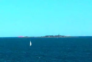
Ferry ports and getting to the region
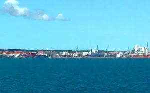 Frederikshavn is a major ferry port on the Kattegat. Stena Line connects the city with Gothenburg, making it possible to combine your arrival with onward travel through western Sweden. Ferries also run from Frederikshavn to Læsø. This makes the city a convenient stop if your trip includes both mainland destinations and time on an island. For ferry connections to Norway, Hirtshals is on the west coast; the port can be combined with a stay near Skagen, with the route passing through the northern landscape.
Aalborg Airport is close to the city center, and the region can be explored by bus or rental car. If you’re visiting several natural and coastal attractions, choosing a base in the region can help you avoid long cross-country trips each day. A northern route can combine Skagen, Grenen, and Råbjerg Mile; an east coast route links Frederikshavn, Sæby, and Hals-Hou. Aalborg and the Limfjord make a destination in their own right, while Læsø deserves enough time for its island trails and coastline. If traveling by ferry, include the port and crossing as fixed parts of your itinerary.
Choosing the right base for your trip
For easy access to Grenen and Råbjerg Mile, consider staying near Skagen. Frederikshavn suits travelers looking to combine a ferry port, the Kattegat coast, and day trips along the east coast. Aalborg is a practical choice if the city and Limfjord are your main focus. Hadsund provides access to the Mariager Fjord; Hals and Hou lie on a coastal stretch with a beach. Sæby adds a harbor town on the Kattegat to your route. A stay on Læsø is a trip in its own right.
The accommodation options in Northern Jutland are spread across different parts of the region. Choose your base according to your priorities and group nearby attractions together each day. This makes it easy to combine Skagen and the shifting dune on a northern route, while Aalborg and the fjord towns open up other parts of the region. If staying overnight on Læsø, make the ferry connection part of your daily schedule; for mainland excursions, Frederikshavn or Aalborg make good bases. Choosing the right location makes it easier to fit coast, city, and nature into a manageable itinerary.
Frequently asked questions about Northern Jutland
Which seas meet at Grenen?
The Skagerrak and Kattegat meet at Grenen. Their currents shape the sandy spit, making the beach a striking natural attraction; swimming is prohibited because of the dangerous currents.
How is Råbjerg Mile different from Grenen?
Råbjerg Mile is a shifting sand dune inland that moves northeast each year. Grenen is a headland shaped by sea currents and deposited sand. Together, the two sites show how different forces shape the landscape of Northern Jutland.
How can I plan a visit to Læsø?
The ferry to Læsø departs from Frederikshavn. Build the crossing into your plans and choose between a longer stay on the island or a day trip with enough time for walks and the return journey.
Where is a good place to stay as a base?
Skagen is close to Grenen and Råbjerg Mile, Frederikshavn is on the east coast and has a ferry port, and Aalborg is on the Limfjord. For Læsø, staying overnight on the island is a good choice if you want to explore its trails and coastline at a relaxed pace.
