
Nordic Walking Routes and Events
In Lubmin, choose from four signposted Nordic walking routes ranging from 4.6 to 10 kilometres. The trails take you along the Bodden shore, through heathland, across the beach or through the forest. Distance and terrain can help you choose; the Lubmin Walking Day adds an April event to the range of routes.
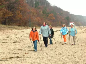 Franka Dietzsch beim Walking-Tag Usedom (Foto: nordlicht verlag)
Route and event facts at a glance
- Four signposted walking routes start and finish at the pier or run through Lubmin Heath.
- The Teufelchenweg is 4.6 kilometres long and follows the shore to the Buttermilchgraben stream, just before Vierow.
- Holter di Polter runs for 5.5 kilometres through Lubmin Heath.
- The Strandläufer is 5.5 kilometres long and follows the sandy beach beside the water to the marina and back.
- The Boddenbrummer combines beach and forest trails over 10 kilometres and is designated as a challenging route.
- Detailed maps are available at the Lubmin Tourist Office and Hotel Seebrücke.
- The municipality of Lubmin lists the Walking Day as an April event.
Four routes, four different trails
For a shorter outing, try the red-marked Teufelchenweg. Its 4.6 kilometres lead from the pier along the shore to the Buttermilchgraben stream, just before Vierow, and back. The route offers a manageable distance as well as views of the Bodden coast. It is the shortest of Lubmin’s four signposted walking routes.
Holter di Polter is the 5.5-kilometre alternative through Lubmin Heath. Its orange markers and woodland setting make it quite different from the shore route. If you’re looking for a beach walk, try the yellow-marked Strandläufer: this route is also 5.5 kilometres and runs from the pier along the water on the sandy beach to the marina and back. The soft sand is its defining feature.
The Boddenbrummer combines beach and forest trails on a 10-kilometre loop. The Tourist Office describes it as challenging; both the start and finish are at the pier. Its greater distance and changing terrain set it apart from the two 5.5-kilometre routes. You can choose based on the distance and scenery you want, rather than relying on the route name alone.
Maps and getting started in Lubmin
For detailed route information, consult the maps at the Tourist Office at Freester Straße 8 or Hotel Seebrücke at Waldstraße 5a. The four routes are marked locally in different colours: orange for Holter di Polter, red for the Teufelchenweg, light blue for the Boddenbrummer and yellow for the Strandläufer. Use the route names together with the markers to find your way.
The pier is the start and finish point for the Teufelchenweg, Strandläufer and Boddenbrummer. For an introduction to the area, the overview of the seaside resort of Lubmin offers more travel information. If you’re planning to spend several days exploring the routes, accommodation in the Lubmin administrative district provides a suitable local base for your outings.
Walking Day: a spring event
The Walking Day adds a shared event experience to the individual signposted routes. The municipality of Lubmin lists it as an April event and names Hotel Seebrücke and the Tourist Office as the organisers.
Lubmin has a long history of Walking Day events: according to the surviving event report, the first was held in September 2002. A separate profile of the Lubmin Walking Day documents those early years and the 2008 programme as a historical snapshot.
More Nordic walking ideas on the Baltic Sea
Lubmin’s four routes show just how much the coastal trail, heathland, sand and forest can differ within a single place. For more inspiration about the sport and things to do, see Nordic walking tips and experiences. The broader overview, Nordic walking on the Baltic Sea, connects this guide to the other information on the topic.
Frequently asked questions about routes and events
Which Nordic walking route in Lubmin is the shortest?
The Teufelchenweg is 4.6 kilometres long. It starts and finishes at the pier and follows the shore to the Buttermilchgraben stream, just before Vierow.
Which route goes through the forest?
Holter di Polter runs for 5.5 kilometres through Lubmin Heath. The Boddenbrummer combines forest and beach trails over 10 kilometres.
Where can I find maps of Lubmin’s walking routes?
Detailed maps are available to consult at the Lubmin Tourist Office, Freester Straße 8, and Hotel Seebrücke, Waldstraße 5a.
When does the Walking Day take place in Lubmin?
The municipality of Lubmin lists the Walking Day as an April event. The historical event page documents earlier editions, including the 2008 programme.
