
Along the Coast of Usedom
After the plan had been haunting the back of my mind for a long time, at the end of August I gave it a chance to take center stage: a coastal cycling tour on Usedom, from north to south—and back.
On a sudden decision, I set the alarm for my usual time on Sunday, and set off at around 6 a.m.
From Karlshagen, where I live and start my ride, the cycle path coming from Peenemünde runs parallel to the outer coast—at varying distances—right up to the Polish border.
At this hour, the packed Karlshagen campsite is still “asleep.” The first rays of sunshine fall on the birch avenue that runs right through the pine forest, until the path reaches the dunes again at the Trassenheide promenade. On the way to Zinnowitz, as the sun gradually climbs higher, several beach access points offer a quick glimpse of the almost mirror-flat water.
The buildings along Zinnowitz’s promenade, still empty of people, glow in the red light of the morning sun. During peak bathing hours, especially around the pier entrance, cyclists need to be particularly considerate of pedestrians; often, the only option is simply to get off and walk.
At the end of Zinnowitz, on the way to Zempin, the coastal forest begins again without a break, with the first small climb. The well-signposted Zempin promenade also passes the cyclist-friendly Dünehaus guesthouse before the route continues along the paved dike to Koserow. Here, at the island’s narrowest point, the distance from the Baltic Sea to the Achterwasser lagoon is only about 300 metres. In that space there is room for an extra-wide dune, a strip of forest, the dike, Federal Highway 111, the Usedomer Bäderbahn (UBB) railway line, and the small dike beside the Achterwasser.
From Koserow to Bansin, the coastal cycle path becomes a continuous forest trail. I ride through beech forest past the Streckelsberg, which is just under 60 metres high and invites you to take a break and climb up to the viewpoint. The relatively short stretch to Kölpinsee, with its ups and downs, offers a taste of what lies ahead. Beside the “Seerose” hotel, cyclists can choose between a manageable flight of steps with a bike “runnel” or a 300-metre detour by bike. Immediately afterwards, the surface of Lake Kölpinsee reflects the morning calm.
The Stubbenfelde campsite marks the start of an unusual stretch: few people expect a 16 percent gradient this far north, and holidaymakers from mountainous regions feel right at home. A sign advises cyclists to dismount on the descent, though there’s no need for one on the climb.
The roller-coaster ride along a well-maintained gravel path through dense mixed forest continues as far as Ückeritz, where cyclists are guided (almost) perfectly across the forecourt by the beach and onto the path to the campsite. Now the route continues for several kilometres on asphalt, with no climbs. To the right are the campsite’s tents, holiday homes and caravans; to the left, a narrow strip of forest runs right down to the beach—there’s no dune here. The tables outside some tents still bear traces of a lively Saturday night…
I’m eagerly awaiting the massif of Langenberg—and it doesn’t disappoint. The excellent gravel path stays close to the coast, though the coastline is only just visible. I feel as if I’m in low mountains, with slopes, climbs and a rest area. A sign beside the path points to Mümmelkensee, a small former lake that has now silted up. Langenberg, also about 60 metres high, is mostly covered in beech trees. Riding through this landscape brings many things to mind, but not a Baltic island with the coast nearby.
To the left, the remains of a holiday camp stand in the forest, unused for 15 years. For me, they are a landmark, because Bansin is not far now. The last stretch over Langenberg follows an asphalt road also used by motor vehicles—the access road to the Forsthaus Langenberg Hotel.
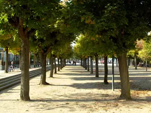 Finally, in Bansin, the continuous promenade begins, running for about eight kilometres through Heringsdorf to Ahlbeck. Recently, the cycle path was strictly separated from the pedestrian area and paved with asphalt over much of its length, so there should be no more confusion here.
The promenade in the municipality now united under the name Seebad Heringsdorf has retained the variety of its former design and adapts to the changing surroundings. The contrast alone between the grand spa architecture and the natural stretches in between is an experience in itself, not to be rushed through at express-train speed. Besides, with traffic this busy, that kind of speed is hardly possible at any time of year.
Cyclists and pedestrians share the final stretch from Ahlbeck to the Polish border. There is plenty of room for a plan that is already quite detailed: a continuous promenade all the way to Świnoujście in Poland. For now, cyclists and pedestrians heading towards Poland have to take a route that is not very bike-friendly from the end of the coastal path, travelling about a kilometre to Federal Highway 111 and the border crossing there. I reach it after just under 40 kilometres in total
.
After a little refreshment, I set off on the return journey, this time along Federal Highway 111. From the border, a shared pedestrian and cycle path runs alongside the road to Ahlbeck. I can pass through both Ahlbeck and Heringsdorf on my bike with unexpected ease, since most of the sidewalks along the highway are open to cyclists. At the edge of Heringsdorf, heading towards Bansin, the cycle path along Federal Highway 111 begins and continues to Koserow.
I trade the natural surroundings of the outward route for the smooth asphalt of the return journey, shared by cyclists, pedestrians and a growing number of inline skaters. After the first stretch along the southern edge of Langenberg, I leave behind the forest that had accompanied the cycle path; I won’t meet it again until later. Between the forest and the turn-off for Schmollensee, the view stretches over the lake to Galgenberg near Pudagla, inviting anyone interested to make a short detour.
The cycle path now runs almost directly beside the road and, in places, close to the UBB tracks. However, it is well protected by safety railings.
The area around Ückeritz offers a few more “bumps,” as people from flat country might call the hilly terrain. Between Ückeritz and Stubbenfelde, the view to the left extends over meadows to the Achterwasser.
During a short photo stop, three Polish cyclists overtake me; I meet them again in Koserow. They readily answer my curious questions. Jan Kowalewski from Świnoujście, his wife and his brother are on a tour around the island. They plan to continue to Wolgast, go via Lassan to Anklam, then return via the island’s southern access road and the town of Usedom—a total of about 130 kilometres, all in one day, of course. It’s part of their training for a cycling marathon in Poland.
In Koserow, I rejoin my outward route on the dike. In Trassenheide, I leave it and take the shorter path along the dunes to Karlshagen. It is rightly not designated as a regional cycle route, since some of its natural, unpaved sections can serve as a test of off-road skills—or you can tackle them by pushing your bike. In any case, I meet plenty of cyclists, as the route is very varied.
Over a leisurely cup of coffee, I look back on the whole route. For the most part, the coastal cycle path, part of the Baltic Sea Cycle Route on Usedom, is very well surfaced, with much of it paved. The signs leave no room for misunderstanding. Cyclist-friendly places to eat line the route, depending, of course, on how densely populated each area is.
But the most important thing was experiencing the island’s diverse natural landscapes. Coastal forest with dunes, hilly mixed woodland away from—but not far from—the bustle of the beach, meadows and inland lakes, dikes and hills. My tour around the coast offered almost everything Usedom’s natural landscape has to offer. Added to that was the atmosphere of the seaside resorts, such as Zinnowitz and the “Imperial Spas.”
For reasonably experienced recreational cyclists, at least a leisurely ride along the coast is manageable. The return journey can then be made by UBB train, whose route always remains within a reasonable distance.
In the future, the island’s tourism operators want to make even better use of the opportunities offered by cycle tourism. This starts with suitable accommodation, continues with developing a continuous cycle route through Usedom’s Achterland (hinterland), and extends to combining public transport with bike rental options.
My conclusion is this: anyone who experiences Usedom only by car cannot truly get to know the island’s diversity. Cyclists aren’t sitting in a “car cinema”—they’re making their own “film,” while doing their eyes more than a little good.
Rainer Höll
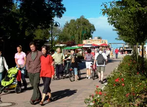 Auf der Promenade ist Schieben angesagt (Foto: Rainer Höll)
