
Bonin: Cycling Routes and Local History
Accommodation in Bonin
Bonin can be explored for trip planning through two specific themes: cycling routes that pass through the village and a local history whose first recorded mention dates back to 1406. Those looking to combine active days with an interest in history can consider the cycling routes and historical points of interest as separate highlights. The routes differ primarily in their total length and the kilometer markers at which they pass through Bonin.
Compare cycling routes through Bonin
The red “Łobeskie Stadniny Koni” cycling route passes through Bonin at kilometer 12.3 and is 18.2 kilometers long in total. The blue MTB cycling route passes through the village at kilometer 5.5 and again at kilometer 28.7; the entire route is 39.7 kilometers long. This makes the blue route 21.5 kilometers longer. The number of times the routes pass through the village also differs: Bonin lies at one kilometer marker on the red route and at two on the blue route. Comparing the routes by distance lets you consider both their total length and where each one passes through Bonin.
Local history and church architecture
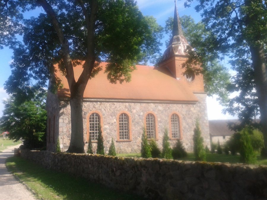
Bonin was first mentioned in a written record in 1406. St. Joseph’s Church in Bonin was dedicated to St. Joseph in 1946. In the broader destination of Labes, the history of the church in Bonin also includes its construction by Luis von Borcke in 1845. Its tower is topped with a Baroque cupola from the 18th century; its furnishings include a Mannerist altar from the 17th century and a Baroque pulpit from the 18th century. The church’s historical dates therefore span the 17th century, its construction and architecture, and its 20th-century dedication.
Labes as the broader setting
In the broader destination of Labes, the Szczecin–Gdańsk railway line and the Gorzów Wielkopolski–Kołobrzeg road connection run through Gmina Łobez. For specific trip planning, it is worth checking the timetable and road conditions on the day of travel, as both can change. These connections provide additional regional context alongside the cycling routes that pass through Bonin.
Two Nordic walking routes start at Polana Jahna in Łobez. Route 1 is 4.5 kilometers long and takes about one hour and ten minutes; Route 2 is 2.8 kilometers long and takes about 45 minutes. The shorter route is therefore also associated with the shorter approximate walking time. The difference between the times is around 25 minutes—a practical comparison for anyone planning their day with both the distance and approximate time in mind.
The blue-marked Szlak Mocy i Tradycji offers a different hiking perspective in the broader destination of Labes. The route is 43 kilometers long and starts and ends in the square in front of Łobez railway station. It runs through the Wysoczyzna Łobeska and Równina Nowogardzka regions, as well as through the municipalities of Łobez and Resko. Its landscape includes fields, mixed forests, hills, valleys, and wetlands. The Rega is crossed several times, and the trail also repeatedly runs close to the river. The route thus features both varied landscapes and several sections alongside the river.
Cycling and cultural history also come together in the broader destination of Labes: the Szlak Dziedzictwa Techniki i Architektury cycling route was created to showcase local architectural and technical heritage from the 19th and 20th centuries. It adds an option with a specific focus on architectural and technological history.
Discover more destinations: Grabowo, Resko, Dobra, Łobez, Rekowo, Klępnica, Orle, Belczna.
Back to the broader travel overview: Labes.

