
A Beach Walk Along Usedom’s Outer Coast
On a Sunday at the end of July 2003, my alarm clock got me going while it was still dark. I had an ambitious goal: to hike the entire outer coast of Usedom in one “go.” I even went without “hooves”—that is, shoes—so I could duck into the water now and then without any consequences.
At the accessible part of the Peenemünde Hook in the northwest of Usedom, where the dunes gradually rise out of the forest and the reed belt gives way to the still-wild beach, there was not yet enough light for photography. In the dawn, I could only make out the wind flats, with their sandbanks often exposed.
After a good half hour, I threaded my way past the early risers (or the ones left over?) from the previous day’s Karlshagen beach volleyball tournament. Even given the “participants’” very leisurely movements, you could be sure the traces of the previous evening’s festivities would be cleared away by the time the first “ordinary” beach walkers appeared.
Between Karlshagen and Trassenheide, in the light of the rising sun, I spotted the first real dune campers. I spent so long wondering how I should ask the young woman lying on her stomach right in my “path” on Trassenheide beach, reading in the first light of day, what had brought her there that in the end I passed her without asking.
Before long, a small truck came into view on the quiet beach. Half in the water, it had just launched a small fishing boat. In Zinnowitz, I took the rare opportunity to photograph the villas on the eastern promenade in the morning glow.
The glassy sea, the beach colored by the clear morning sun, the groynes between Zempin and Koserow as a photographic subject, and nearly three hours of brisk walking prompted me to take my first break on the almost deserted beach. From here, I made a detour over the dune to the island’s narrowest point, where the outer dike and cycle path, Federal Highway 111, the railway line, and the inner dike by the Achterwasser are squeezed into a span of barely 300 meters. A little over 100 years ago, a storm surge breached the island here for the last time. Since then, however, the outer coast has been reinforced so much that, hopefully, a repeat can be ruled out.
The Koserow fishing boat, with a cormorant floating behind it, signaled a distinctive stretch of coast: Streckelsberg. At just under 60 meters, it is one of the island’s three highest elevations, along with the almost equally high Langenberg and Golm. Without the active coastal protection measures of recent years, it would have been left to erosion; but beach nourishment and stone embankments have so far managed to hold back the natural forces here.
After passing the Seerose beach hotel, the coast at Kölpinsee drops back down to dune level for a while, only to present a striking sandy cliff at Stubbenfelde. Unfortunately, the sun had also begun playing hide-and-seek among the clouds.
Here, between Kölpinsee and Ückeritz, I first realized that there are spots on the beach that are difficult to reach by car. Accordingly, they remain untouched and sparsely visited—hidden gems.
At Ückeritz’s steep coast, with its two restaurants, nothing remains to suggest the aftermath of the 1994 storm surge, when the foundation slab of one of them was already partly hanging in midair…
The beach stretches for kilometers between Ückeritz and Langenberg, with the Ückeritz campground as a constant companion. As if to illustrate the point, the sun now disappeared completely, and a few raindrops actually fell.
Where Langenberg begins—and lives up to its name—the hiker passes a sports beach, easily reached by car from Federal Highway 111, between the Schmollensee junction and Bansin. Here, in the midst of nature, the fast boats add a touch of exclusivity.
The hill itself, with its cliff, forms one of the most rugged stretches of the entire coast. Fallen trees, tiny coves, and embedded erratic boulders bear witness to the coast’s continuing dynamism, as it claims a new piece of land here every year.
Speaking of dynamism, by this point at the latest I had begun to reconsider the idea of walking barefoot a little more carefully. I slowed my pace not only because of the natural beauty. And, by my own calculations, I still had a third of the way to go.
The seaside resort of Bansin announced itself with beach chairs and dark clouds, which soon gave way again to the midday sun.
Here began the final leg of my trek, a stretch of coast with a busy beach all the way along, alternating views of resort-style promenades and dune sections covered with vegetation or planted with greenery. The Kulm hill at Heringsdorf signaled the approaching pier, along with a “little place” I had been longing for after the long, crowded coastal stretch since Bansin’s fishermen’s beach…
Ever since passing Langenberg, I had been able to see my destination—the Polish border—in the shape of the Świnoujście harbor cranes, but it was approaching only slowly. What was new for me was the fact that I completed the whole route without a break and could also take in the stretches between the three seaside resorts. My dragging gait and pained expression, only partly concealed by old-fashioned sunglasses, drew some peculiar looks from summer visitors, despite their generally tolerant outlook. But my own gaze was fixed on the distance, and I got a chance to rest it once more at the Ahlbeck pier, Usedom’s landmark.
The final kilometers to the border were all stubbornness and determination. I fixed my sights on a large festival tent on the beach, which is almost 100 meters wide here, as my next short-term goal.
From Ahlbeck to the Polish border, the beach is flanked by low dunes and woodland.
At last: I reached the border fence, which still existed at the time. I found a spot in the dunes and took my sandals out of my backpack so I could cover the remaining stretch to the Ahlbeck-Grenze station of the Usedom Island Railway (UBB) with shoes on again. The path initially leads back the way I came, as part of the future promenade that is intended to run from Świnoujście directly along the dune to Ahlbeck.
Even as I write these lines, the impressions of this hike remain vivid. I am reminded once again of how varied the island is, not only inland, but also in the shape of its coastline. And in some places, changes can be observed every year. This hike remains an unforgettable experience, and for anyone still considering it: the UBB, with its many stops, runs close to the coast almost everywhere…
Peter Reinhard
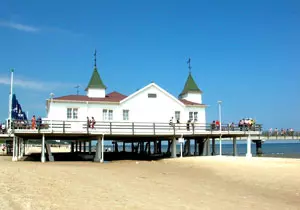 Seebrücke in Ahlbeck/Usedom
Photo: © Peter Reinhard
Seebrücke in Ahlbeck/Usedom
Photo: © Peter Reinhard
