
Storm Surges on the Baltic Sea
Flood events have occurred and continue to occur naturally along the Baltic Sea coast. Unlike the North Sea, the Baltic Sea has no tides. Therefore, the term “storm tide,” used in the North Sea, does not apply to the Baltic Sea, even though Baltic Sea flooding is often described this way. In the Baltic Sea, a flood event always occurs in connection with a storm, which is why it is called a storm surge here.
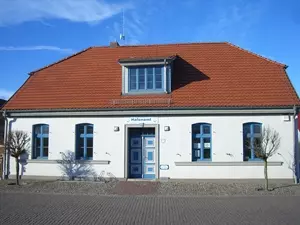 Hochwassermarke von 1872 in Greifswald-Wieck
Photo: © oben: Wikipedia.de_Axt_CC BY-SA 1.0; unten nordlicht verlag
Hochwassermarke von 1872 in Greifswald-Wieck
Photo: © oben: Wikipedia.de_Axt_CC BY-SA 1.0; unten nordlicht verlag
How storm surges develop
When a westerly storm lasts for several days, pushing Baltic Sea water eastward, the water piles up in the eastern bays of the Baltic Sea, particularly in the Gulf of Finland, and triggers a severe storm surge there. St. Petersburg has been flooded this way several times, for example. At the same time, North Sea water flows into the western Baltic Sea. When the westerly storm subsides, water levels rise simply because the Baltic Sea water sloshes back westward. If the wind suddenly shifts to the east as well, the backwash effect intensifies, and the water also encounters the North Sea water that has flowed in. For these reasons, all low-lying coastal areas are at risk, especially those around the western and eastern Baltic Sea—in other words, almost the entire coastline from southwestern Sweden through the Danish islands, Schleswig-Holstein, Mecklenburg, Western Pomerania and on to Poland.
Severe flood events in the Baltic Sea
Flooding in 1044 is mentioned in Rügen chronicles. The first “flood” in the Baltic Sea for which more detailed records survive was the so-called All Saints’ Day Flood of 1304. It apparently destroyed the land connection that had existed until then between the islands of Rügen and Usedom; the present-day island of Ruden is probably what remains of it. The consequences were particularly severe at the time because no coastal protection measures existed. The most severe storm surge to date occurred in 1872.
The storm surge of November 13, 1872
had devastating effects along the entire western Baltic Sea coast. With a water level 2.70 meters above sea level, it was the highest flood event ever recorded in the Baltic Sea. A total of 271 people died. The islands of Usedom and Vilm were temporarily split apart, while the Prerowstrom between the Darß and Zingst silted up. It is considered a once-in-a-millennium flood. The water levels from that time are still marked on buildings today, for example in Warnemünde and Greifswald-Wieck. The towns along the Baltic coast of Schleswig-Holstein were affected most severely.
Coastal protection and flooding after 1945
.webp) The 1872 flood in particular, as well as subsequent events in 1903/04 and 1913/14, led to the systematic construction of coastal protection works. Dikes were built, and dunes were reinforced and secured. As a result, the impact of storm surges was significantly reduced, especially after 1945—for example, in 1954, 1995 and 2006. One complex structure built partly for flood protection is the dam across the Gulf of Finland. It not only protects St. Petersburg from flooding with floodgates, but also helps ease traffic congestion. The Greifswald-Wieck flood barrier was commissioned in 2016.
The 1872 flood in particular, as well as subsequent events in 1903/04 and 1913/14, led to the systematic construction of coastal protection works. Dikes were built, and dunes were reinforced and secured. As a result, the impact of storm surges was significantly reduced, especially after 1945—for example, in 1954, 1995 and 2006. One complex structure built partly for flood protection is the dam across the Gulf of Finland. It not only protects St. Petersburg from flooding with floodgates, but also helps ease traffic congestion. The Greifswald-Wieck flood barrier was commissioned in 2016.
